
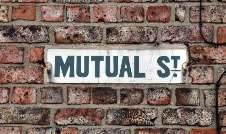
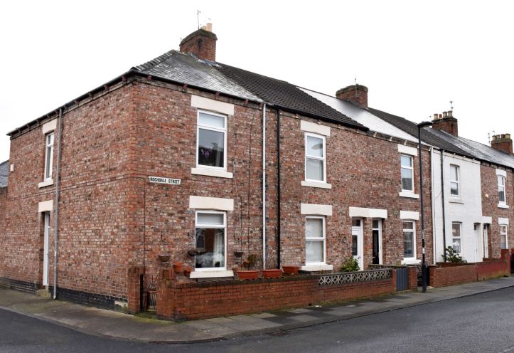
Some street names just make you wonder. If you take a close look at a map of the terraces in Wallsend from about 1870 onwards, you will notice some distinctive names: Mutual Street, Equitable Street and Rochdale Street. All of these suggest an equitable society and some form of mutual cooperation. Rochdale reflects the principles and values laid down by the Rochdale Pioneers in the 1840s.
These streets tell the story of Wallsend’s own aspirational artisans who spent their earnings in their own cooperative society. They were families who got together and put their dividends and savings towards providing mortgage loans so they could own their own homes.
Cooperation
Wallsend Industrial Co-operative Society was founded in 1862 by pioneers Robert Douglass (1832-1900) and Thomas Blenkinsopp (1822-1891). Cooperative members shopped at their own store and benefited from any profits generated. In July 1867 Wallsend’s cooperative society had 325 members, annual sales of over £10,300, profits over £1,230 and paid an average dividend of two shillings fourpence halfpenny (Robertson 1912 p54).
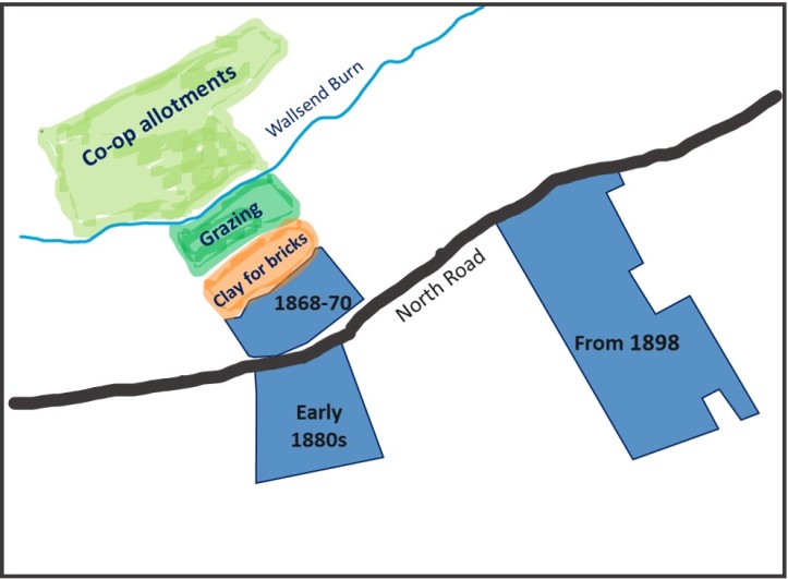
In 1868 Wallsend’s pioneers bought 13 acres, including land for allotments north of Wallsend Burn and some grazing land. The land was held by Douglass, Blenkinsop and Thomas Hopper as trustees on behalf of the cooperative and according to Robertson some subterfuge was required to conceal who the purchasers were (1912, p56). Some of the society’s members were not best pleased to discover their hard earned money had been ‘speculatively’ invested in land.
“No phase of applied co-operation had more interest for Mr Douglass than the development of land and building of workmen’s dwellings, in which Wallsend society has been conspicuously successful.” Robertson (1912, p24)
Wallsend’s society was also successful in trade during the second half of the nineteenth-century. They were was able to open impressive three-storey business premises in 1876.
“The trades carried on included groceries and provisions, greengrocery, butchering, hardware, draperies, boots and shoes, tailoring, shoemaking, dressmaking and millinery; with shops on the ground floor, and offices and warehouses on the first floor and a large hall…” (Robertson 1912 p60)
In addition, the cooperative society had warehouses, stables and a library and reading room. The society’s activities were profitable and surpluses were available to ‘retain within the movement’ (Robertson 1912 p61).
Growth of Wallsend
It is not hard to see why there would be a high demand for housing and why the pioneers were interested in ways to reduce housing costs for their members. Wallsend’s nineteenth-century industrial development was based on coal mining and the River Tyne. Shipbuilding and engineering became the area’s most famous industries, but there were also brick works, iron works, cement works and lime works in the vicinity. These can be easily identified on Ordnance Survey maps published in the 1890s (e.g. https://maps.nls.uk/view/101027580 ).
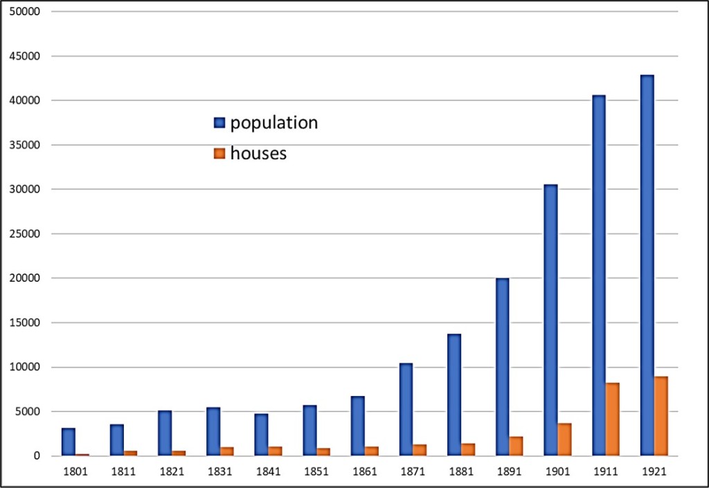
The population growth locally outstripped the housing available. The census figures show 6,715 people in 1,079 houses in 1861, 13,737 people in 1,430 houses in 1881 and 30,537 in 3,669 houses in 1911 (Richardson 1923 p496). According to Robertson, much of the workers’ housing available in the 1860s was in old colliery rows so poorly constructed the floors had a tendency to flood when it rained (1912, p55).
The first two phases
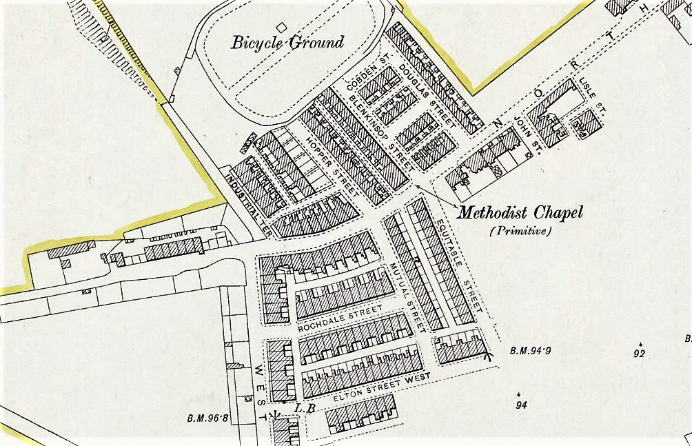
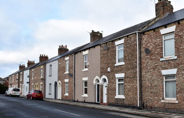
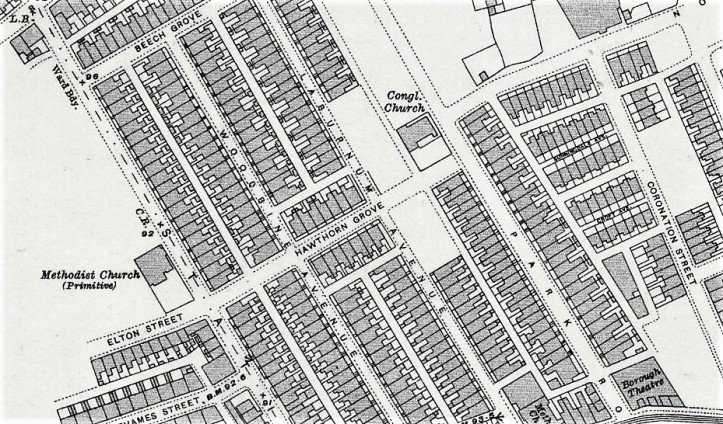
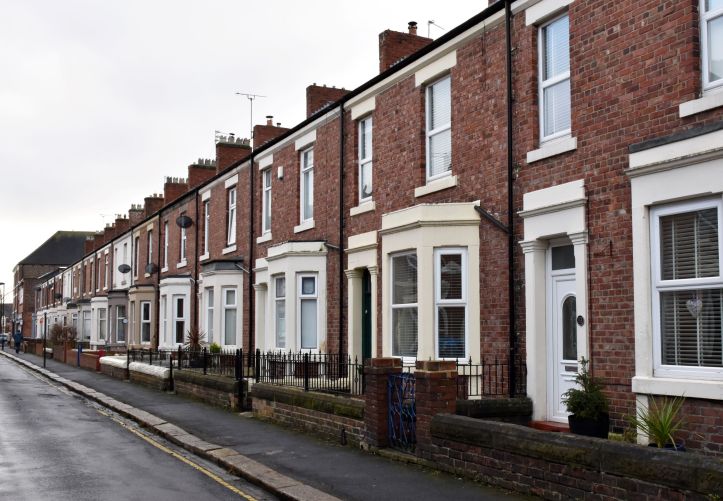
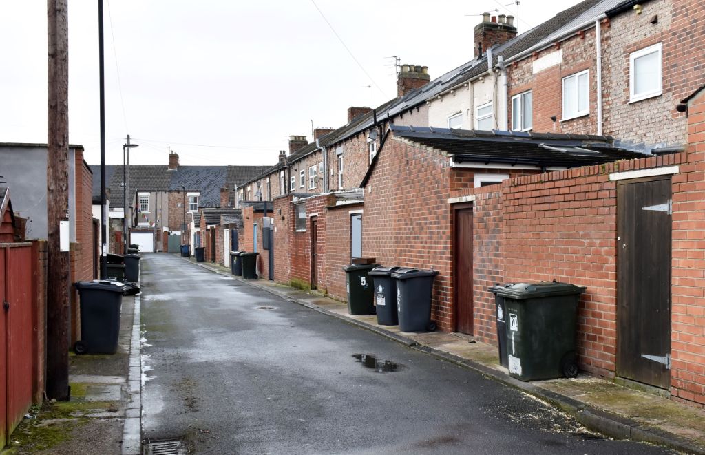
The first phase of building by the society was between 1868-70 to the north of North Road and some of the streets were named after Wallsend’s own pioneers Hopper, Douglass and Blenkinsopp (Robertson 1912 p56). Others were named Harrington Street, Cobden Street and some houses faced on to the North Road. These were small terraced houses with upstairs rooms (not Tyneside flats). Most opened straight on to the street and had back yards opening on to a lane. There were two terraces associated with Hopper Street where some houses appear larger and there were front gardens.
The houses were built of bricks made using clay from the society’s own land, manufactured by their own employees and built by them too. The clay pit was where the field and bicycle track is shown on the 1897 OS map extract above (later a football field). The houses were sold at cost and members were advanced mortgages of 75-80%; some members helped to pay these off by using their quarterly dividend (Robertson 1912 p56).
Robertson (1912) notes that Blenkinsopp died in 1891 and Douglass in 1900. The 1881 census has a Thomas Blenkinsopp, 59, living at 6 Blenkinsopp Street with his wife Margaret, 59, and three adult sons. Thomas was a grocer, perhaps with the cooperative store, and the sons all had skilled trades: a joiner in a shipyard, a foundry moulder and a foundry plater [1881 census RG11/5072 folio 17, page 33]. Widow Margaret Blenkinsopp, 69, is in Blenkinsop Street on April 5th in 1891 with metal moulder son William, 32, and granddaughter Anne, 6; they had four rooms [1891 census RG12/4221 folio 73, page 26]. In the 1891 census Robert Douglas, 59, was employed as the Cooperative Society Secretary, and lived, with his older brother William and niece Margaret, in a cooperative-financed house at 6 Industrial Terrace, Hopper Street [1891 census Wallsend RG12/4221, folio 76, page 31]. The number of rooms was not noted, suggesting there were five or more.
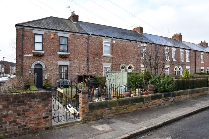
In 1881 a further 3.5 acres of land was purchased for a second phase of building. These streets were adjacent and south of North Road: Rochdale Street, Mutual Street, Equitable Street, Elton Street West. These plain houses had a small front garden separating the front of the property from the street. Most were sold before completion (Robertson, 1912, p61).
The third phase
The Zion Chapel field, eight acres, was bought from Dame Allan’s charity, plus seven acres south of that for further housing development from 1898. The society hoped to buy land opposite the Buddle schools, but the owners refused to sell (Robertson 1912 pp68-9).
The Wallsend society did use contract builders as well as their own employees for part of this phase and also sold plots to members to build their own houses. The streets were laid out at an early stage, but the houses were actually built in a more piecemeal fashion than their fairly uniform appearance suggests.
Most of the terraced houses in the Woodbine Avenue and Laburnum Avenue area are a little more upmarket than the earlier developments with more in the way of architectural detail and have bay windows. There were also some Tyneside flats built as part of the High Street East development, which the society rented out.
Wallsend cooperative was subject to the same external fluctuations as other house developers. Robertson (1912) notes a severe depression in 1902-5 and yet sales reached their highest ever in 1908 (p84). In 1909 a downturn meant there was a shortage of work exacerbated by shipbuilding and mining disputes. In 1912, at the time Robertson compiled the Jubilee volume, the society’s financial books were very healthy.
https://maps.nls.uk/view/132280028 NLS maps (CC-BY)

Wallsend to Walkerville
Wallsend Industrial Co-operative Society successfully provided a better-class of housing for its members and a way for members to invest and own their own homes. The enterprising efforts of the society are likely to have raised expectations locally of what good housing should look like. The houses today are still well cared for with previous and current owners having invested time and energy in making these houses comfortable homes.
Wallsend cooperative maintained an interest in providing mortgage capital and developing decent houses for their members in the period before the First World War. The society was a prominent backer of a model housing exhibition held under the auspices of the National Housing Reform Council in 1908. Walkerville was an early example of small-scale town planning prior to the Housing, Town Planning, &c. Act 1909 and was developed along Garden city movement lines. A housing tale for another blog.
References
Census entries obtained via Find My Past https://www-findmypast-co-uk.
Primitive Methodist chapel, Wallsend, North Road. Tyne and Wear HER(7939): https://twsitelines.info/SMR/7939
Richardson, William (1923) History of the parish of Wallsend: The ancient townships of Wallsend and Willington. The Northumberland Press.
Robertson, F. Ed. (1912) Wallsend Industrial Co-operative Society Limited Jubilee 1862-1912: History and handbook. [Newcastle Libraries, Local Studies].
Wallsend Local History. Tyne and Wear Archives. https://twsitelines.info/local-histories-w
Wallsend Industrial Co-operative Society Limited. Committee, Board of Management and Quarterly meetings minutes 1901-12. [Tyne and Wear Archives].
Maps
NLS maps OS six-inch Northumberland Sheet XCVIII.NW Revised: 1894 to 1895, Published: 1899. https://maps.nls.uk/view/101027580
NLS maps OS 25-inch Northumberland (Old Series) LXXXIX.13 Revised: 1895, Published: 1897 https://maps.nls.uk/view/132268445
NLS maps OS 25-inch Northumberland (New Series) XCV.6 Revised: 1913, Published: 1916
https://maps.nls.uk/view/132280028

Except where otherwise stated, The Past and Other Places by JKW (Kay Williams) is licensed under a Creative Commons Attribution-NonCommercial-ShareAlike 4.0 International License

[…] https://thepastandotherplaces.wordpress.com/2023/01/28/housing-the-workers-in-wallsend/ […]
LikeLike